What is BaseCamp?
|
Garmin BaseCamp is software for use with Garmin GPS navigation devices and Garmin-format maps facilitating communication between mobile devices and computers. It is used for planning, managing , documenting, and sharing trips, routes, tracks and waypoints.
It is available at no charge, in Mac and Windows versions, at www.garmin.com It is interface software. In addition, you will require Garmin-format maps to use it effectively. |
Where can I get maps for use in BaseCamp?
|
Garmin maps can be purchased from Garmin itself or Garmin dealers. Purchasing from Garmin direct allows you instant access via download. Other vendors (as well as Garmin) will sell an access card for downloading, or maps on other media such as DVD or SD card. Older Garmin units may not have the capacity to utilize downloaded maps initially, you may have to purchase a DVD first. As the BaseCamp copyright indicates it first published in 2008, we can assume that an 'older' unit is one designed before 2008.
Maps in Garmin format may be purchased from third-party vendors. These are often the best maps for locations other than North America (USA and Canada) and Europe. For example, superior maps of Mexico can be purchased from BiciMapas Garmin format maps can be found for free at online sources. Acquiring Garmin routable maps for free is suggested only for advanced users. If you already own a Garmin device you may have access to the maps on that device through BaseCamp, but this feature is not available on older GPS devices. If your GPS came with 'lifetime' or 'onetime' upgrade access, you may be able to download Garmin maps to your device as well as your computer for use with BaseCamp. Although map products may be used on multiple computers, only maps purchased on an SD card are usable in multiple devices. Other media require that you associate the map product with one GPS device only. SD card format maps from Garmin have limitations, they cannot be upgraded and in most circumstances cannot be printed. This not the case with maps purchased on other media and then placed on an SD card for use in one (only) GPS. |
How do I get my locations (waypoints) into BaseCamp? |
Locations in the Garmin world are called 'waypoints' , though they are also known as 'points', 'POIs', 'locations', 'favorites' or 'places'. We'll use the waypoint term to describe specific locations that you want to save, create and use to make routes in the program.
If you have a file in a Garmin format (.gdb or .gpx) simply open it in BaseCamp. When a file is opened , it is automatically saved and will appear in the 'Library' pane. Files used in Garmin's predecessor to BaseCamp, MapSource, will be in Garmin .gdb format, so can be opened directly. If you have file in a competitor's product such as Microsoft Streets and Trips or Delorme Street Atlas, it will need a third party 'helper' program. such as GPS Utility or GPS Babel to convert the file to a Garmin compatible format so that it can then be opened in BaseCamp. A spreadsheet file (MS Excel) can be saved in the .csv format and converted to a Garmin format via these third party helper programs or the Garmin POI Loader program. It's free. If you wish to import 'placemarks' in Google Earth into BaseCamp, save them as a .kml or .kmz file, then import this file into BaseCamp via FILE > IMPORT. If you do not have waypoints in file format that can be brought into BaseCamp, they can be created from within BaseCamp. |
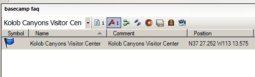
How do I create waypoints?
Waypoint in the data pane
|
Whoa Nellie! One at a time.
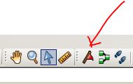
The tool for making a waypoint is a little red flag. Click on this tool and then click anywhere on the map to make a waypoint. If will show up in your waypoint list in the Library and Devices Area, the place where you manage your data. When you create a waypoint it is saved. No additional saving action is required.
This means of creating a waypoint is useful when you do not know exactly where you are going, i.e. you do not have an address. For example, imagine you are going to Zion National Park to take a picture of any entrance sign. If you search for that park using the search tool, the three entrances and two trailheads deep within the park will appear on the map. 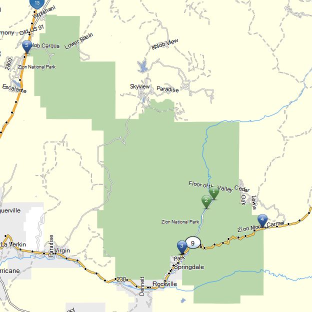
|
|
Look at these options, then use the waypoint tool to select a waypoint most convenient to your planned approach to that park. You can click on the waypoint tool in the upper menu bar and then on your preferred location on the map, or you can click on the waypoint tool that pops up when you click on a map location, either where it appears in the search pane or the map location.

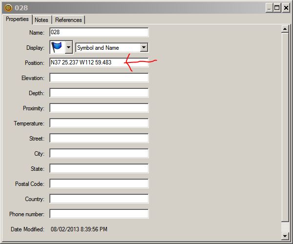
A waypoint is deleted or edited by right clicking on it in the data pane. To edit, select 'Open'. You can also Cut, Copy, Duplicate, Rename and Remove from current list. Refer to 'Managing Waypoints' for more information on these actions.
|
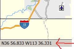
How do I find a specific GPS coordinate?
latitude and longitude, which always appear in the lower left corner of the screen, indicating the coordinates of the current position of the cursor
|
Make a waypoint by clicking on the waypoint tool then clicking anywhere on the map. Right click on that waypoint, then select 'Open'. In the editing box that appears, edit the coordinates shown to the coordinates you want to make into a waypoint. While you have the box open, you can change the name, the symbol, or add additional information. You cannot use the 'search' function to search GPS coordinates, you locate them by this editing process.
|
